File Details |
|
| File Size | 1.3 MB |
|---|---|
| License | Freeware |
| Operating System | Windows 2000/9x/Server 2003/XP |
| Date Added | April 23, 2005 |
| Total Downloads | 1,511 |
| Publisher | Bill Friedrich |
| Homepage | TerraClient |
Publisher's Description
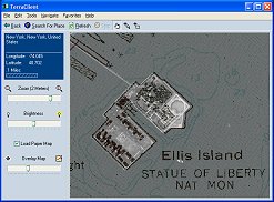
TerraClient allows viewing and printing of ground level satellite photographs of the United States. Featured is a unique map overlay option that automatically superimposes a "paper" roadmap over the satellite photos. This map overlay option has been designed to help users identify indistinct land features in the satellite photos. All map and photographic data is downloaded in real time from Microsoft’s free TerraServer web service.
Latest Reviews
isaacg reviewed v1.3.3 on Jun 28, 2005
I haven't used this for quite a while, but I imagine its totally outclassed by the new Google Earth:
http://earth.google.com/
brazen weep reviewed v1.1 on Jul 30, 2003
What a great idea! This is such a great way to use and browse through Microsoft's TerraServer images. It makes the process much faster, and it's ability to quickly maximize the map view when the window maximizes comes in handy. Very cool. (It would also be great to have a drop-down on the "Search for Place" dialog that would remember recent searches.) Thanks for sharing, nice job!